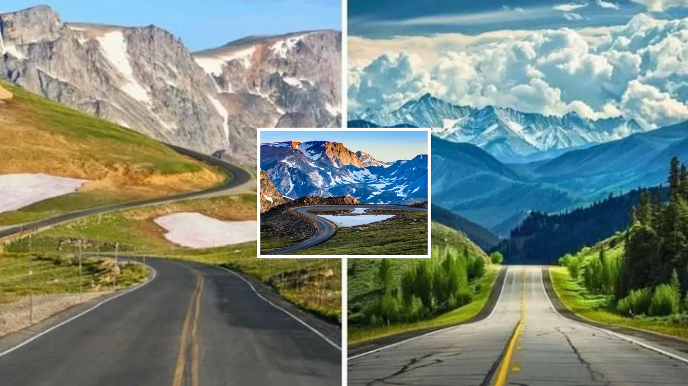
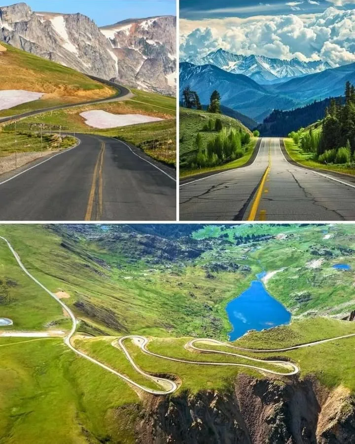
Dubbed “the most beautiful drive in America” by the late CBS correspondent Charles Kuralt, the Beartooth Highway is a bucket-list journey through the heart of the northern Rockies. Spanning approximately 68 miles (109 km) along U.S. Highway 212, this National Scenic Byway connects the charming town of Red Lodge, Montana, to the Northeast Entrance of Yellowstone National Park near Cooke City, Montana, with a brief dip into Wyoming. Climbing to a breathtaking 10,947 feet at Beartooth Pass, the highway offers a dramatic ascent through alpine tundra, glaciated peaks, and shimmering glacial lakes, earning its nickname as the “Highway to the Sky.” Whether you’re a road-trip enthusiast, a wildlife lover, or a seeker of jaw-dropping vistas, the Beartooth Highway promises an unforgettable adventure.
A Road Like No Other
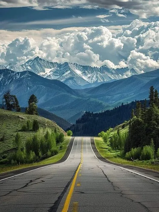
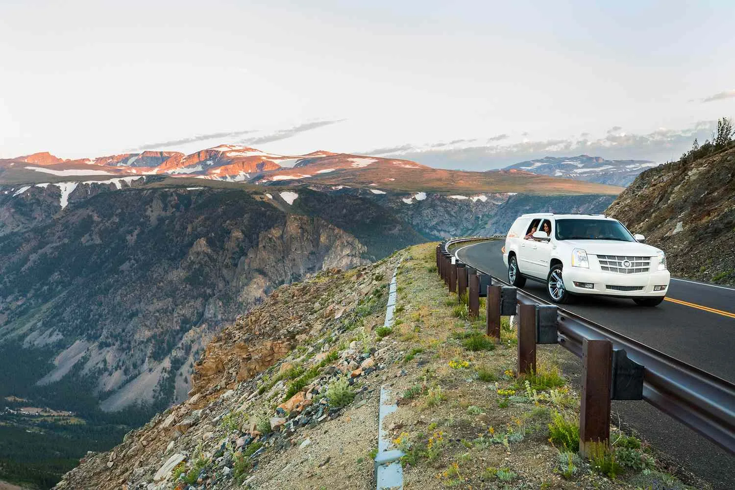
The Beartooth Highway is a marvel of engineering and natural beauty, winding through the Absaroka-Beartooth Wilderness, a 944,000-acre expanse of rugged mountains and pristine backcountry. Completed in 1936, the highway traces a route once crossed by Civil War General Philip Sheridan in 1872, guided by local hunter Shuki Greer. Its steep switchbacks and hairpin turns climb from 5,570 feet in Red Lodge to the dizzying heights of Beartooth Pass, making it the highest-elevation highway in the Northern Rockies (10,947 feet in Wyoming, 10,350 feet in Montana). This dramatic elevation gain takes drivers above the tree line into a stark, otherworldly alpine tundra, a rare landscape accessible by car in the U.S.
The highway’s seasonal access, typically from Memorial Day to mid-October, is dictated by its high altitude and unpredictable weather. Snowstorms can close the road even in July, and snowbanks often linger along the pass into summer. The Montana Department of Transportation (MDT) and National Park Service (NPS) coordinate to clear the road each spring, a massive undertaking that can take weeks due to heavy snowpack—sometimes exceeding 126 inches at the summit. Travelers are advised to check road conditions via the MDT 511 Traveler Information map or by calling the Red Lodge Visitor’s Center at (406) 446-2610.
Why It’s Special
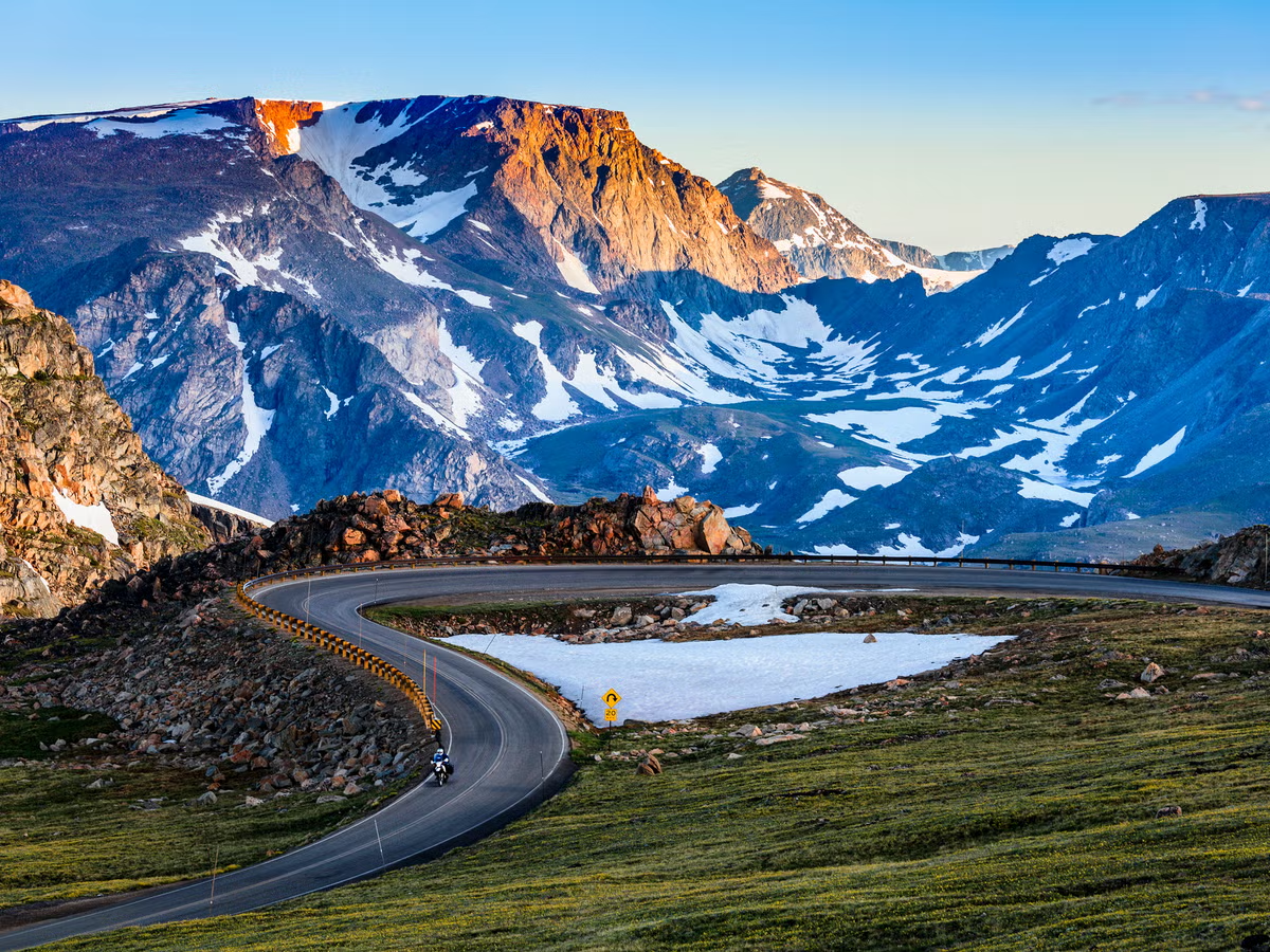
Alpine Landscapes: The Beartooth Highway transports drivers into a high-altitude world of alpine tundra, where trees give way to vast plateaus dotted with wildflowers, glacial lakes, and snow-capped peaks. In late June and July, the tundra bursts into color with shooting stars, columbine, and Indian paintbrush, thriving in a harsh climate where plants adapt like desert flora to conserve water. The landscape, shaped by ancient glaciers, features 20 peaks over 12,000 feet, including Granite Peak, Montana’s highest at 12,799 feet.
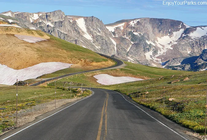
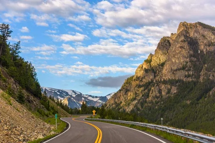
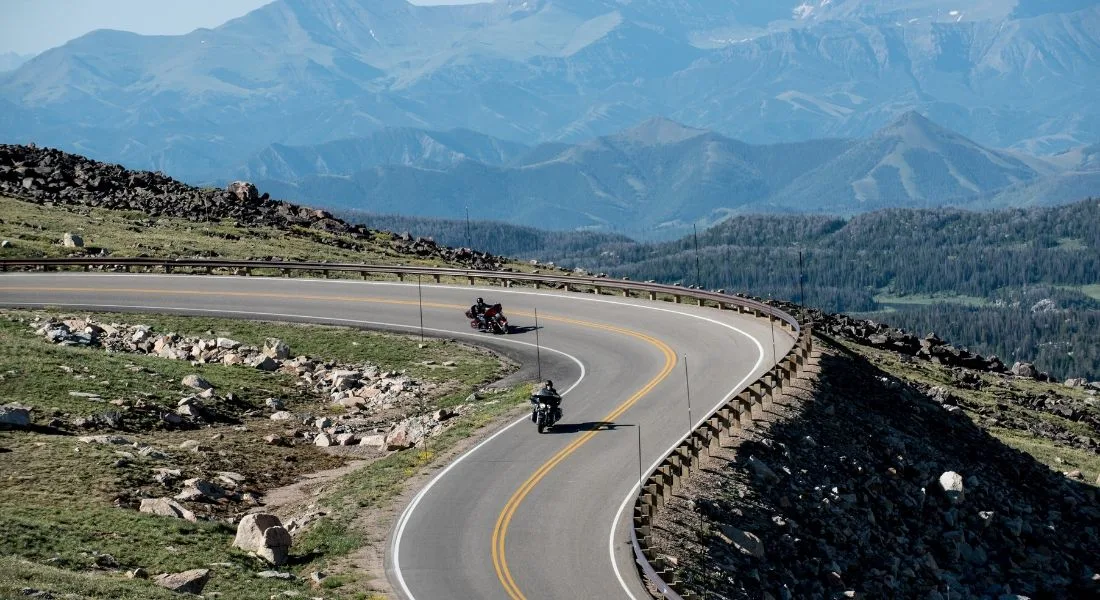
Switchbacks & Vistas: The highway’s hairpin turns and steep grades—rising nearly 5,400 feet in just 12 miles from Red Lodge to the pass—offer heart-pounding driving and unparalleled views. Key overlooks like Rock Creek Vista Point (9,190 feet) provide wheelchair-accessible trails and interpretive panels showcasing the Rock Creek Canyon and Hellroaring Plateau. From Beartooth Pass, panoramic vistas stretch across the Absaroka and Beartooth Mountains, with the iconic Bear’s Tooth, a pyramidal spire carved by glaciers, visible from designated pullouts.
Wildlife: The Beartooth Corridor is a haven for wildlife, with opportunities to spot mountain goats scaling cliffs, marmots scurrying across rocks, elk grazing in meadows, and, if you’re lucky, grizzly bears or black bears foraging in the distance. Bighorn sheep, moose, mule deer, and even wolves also inhabit the region, particularly in the adjacent Absaroka-Beartooth Wilderness. For safety, carry bear spray when hiking, maintain a safe distance from animals, and never feed wildlife.
Seasonal Access: The highway’s high elevation means it’s only open from late May to mid-October, weather permitting. Even in summer, temperatures at the summit can drop below freezing, and sudden snowstorms or high winds are common. Travelers should bring layers, check weather forecasts, and be prepared for rapidly changing conditions.
Points of Interest Along the Route
-
Red Lodge, Montana: This charming mountain town, with a population of about 2,500, is the eastern gateway to the Beartooth Highway. Once a coal-mining hub, Red Lodge now boasts a historic downtown with 19th-century buildings, the Pollard Hotel, and outdoor outfitters for hiking, skiing, or fishing. Stop at the Red Lodge Visitor’s Center for maps and road updates.
-
Beartooth Pass (10,947 feet): The crown jewel of the highway, this high point offers sweeping views of glaciated peaks, alpine lakes, and the Bear’s Tooth spire. A short road on the north side leads to a photo-worthy sign marking the pass.
-
Top of the World Store (9,396 feet): Located halfway between Red Lodge and Cooke City, this remote outpost in Wyoming offers snacks, souvenirs, gas (when available), and even Wyoming invasive species boat inspections. It’s a welcome oasis in the wilderness, perfect for a quick break.
-
Beartooth Lake: A serene alpine lake below Beartooth Butte, a limestone and sandstone formation, this spot offers camping, fishing for brook trout or Rocky Mountain grayling, and trails like the Beartooth High Lakes Trail for hikers.
-
Cooke City, Montana: A rustic town of just 100 residents, Cooke City lies 4 miles from Yellowstone’s Northeast Entrance. With lodges, restaurants like Antler Lodge, and outfitters, it’s a great base for exploring the highway or nearby Lamar Valley, a prime wildlife-viewing area in Yellowstone.
-
Yellowstone National Park: The highway ends (or begins) at the park’s Northeast Entrance, leading directly to Lamar Valley, known for its herds of bison, wolves, and bears. The park’s proximity makes the Beartooth Highway a stunning gateway to Yellowstone’s wonders.
The Name: Beartooth
The highway and surrounding mountains are named after Beartooth Peak, a striking spire resembling a bear’s tooth, carved by glaciers in the Beartooth Range. The peak, visible from overlooks like the Beartooth Loop National Recreation Trail, gave its name to the Absaroka-Beartooth Wilderness, a 943,377-acre expanse of rugged peaks, glacial cirques, and pristine lakes. The region’s wild beauty and biodiversity make it a paradise for hikers, anglers, and backcountry adventurers.
Tips for Travelers
-
Drive Slowly: The highway’s steep grades and sharp curves demand caution, especially for RV or motorcycle drivers. Allow at least 2 hours for the 68-mile drive from Red Lodge to Cooke City, longer if you stop to hike or take photos.
-
Bring Layers: Temperatures can plummet at higher elevations, even in summer. Pack warm clothing and check weather updates via Montana Traveler Information or Wyoming Travel Information Service.
-
Watch for Snow: Snowbanks line the road into July, and sudden storms can close the pass. Check road conditions before setting out.
-
Fuel Up: Gas stations are scarce between Red Lodge and Cooke City. Fill up in either town and consider carrying extra fuel for peace of mind.
-
Respect Wildlife: Keep a safe distance from animals, use binoculars for viewing, and carry bear spray for hikes. Follow Leave No Trace principles to protect the fragile tundra.
-
Explore Side Routes: For a longer adventure, connect to the Chief Joseph Scenic Byway (Wyoming Highway 296) near Cooke City, which leads to Cody, Wyoming, and offers views of Sunlight Basin and Clarks Fork Canyon.
A Journey Worth Taking
The Beartooth Highway: Driving to the Sky on the Orphaned Road
The Beartooth Highway is more than a road; it’s a portal to the wild heart of the Rockies. From the charming streets of Red Lodge to the windswept heights of Beartooth Pass, every mile offers a new perspective on nature’s grandeur. Whether you’re marveling at the Bear’s Tooth, spotting a mountain goat, or gazing across the tundra from the Top of the World, this drive is a reminder of why some journeys are as much about the path as the destination.
Plan your trip between late May and mid-October, pack your sense of adventure, and let the Beartooth Highway take you to the sky. It’s a drive you’ll never forget.